One Bullion Advances Maitengwe Gold Project Toward Field Verification and Planned Drill Testing One Bullion Limited Fri, November 13, 2026 at 7:30 AM EST 12 min read OBUL.V -1.43% GC=F +0.22% One Bullion Limited 11,654 Line-km Airborne Survey Supports Target Evaluation Beneath Kalahari Cover; Phased Program Proposed to Test Geological and Geochemical Evidence Before Drilling
TORONTO, Nov. 13, 2026 (GLOBE NEWSWIRE) -- One Bullion Ltd. ("One Bullion" or the "Company") (TSXV: OBUL), a gold exploration company holding complete ownership of three prospective exploration projects in Botswana, today announced an exploration update on its wholly owned Maitengwe Gold Project in northeastern Botswana and outlined the next proposed phase of work, following receipt of the final dataset from its 2026 high-resolution airborne geophysical survey. The Company holds the project through its wholly owned Botswana subsidiary, Premier Gold Resources (Pty) Ltd. Maitengwe comprises prospecting licenses PL 012/2018 and PL 235/2016 and has an area of approximately 58,075 hectares (580.75 km²).
"Maitengwe is now moving from a large, underexplored land position to a series of specific geological questions that we can test in the field," said Adam Berk, Chief Executive Officer of One Bullion. "The geophysical program has given us a much clearer view of the concealed rock architecture beneath Kalahari cover. Our focus is on testing the structural positions that may matter for gold, such as contacts, bends and intersecting trends. We intend to verify the geology, establish where our sampling methods are effective and advance only the most compelling targets to trenching and RC drilling. That staged approach is designed to deploy capital carefully while building a technically credible exploration pipeline at Maitengwe."
An 11,654 line-kilometer airborne magnetic-gradient and radiometric survey, flown at 50-meter line spacing in July 2026, provides an enhanced framework for geological interpretation across the two-license Maitengwe project.
The property lies within the Archean Francistown Granite–Greenstone Complex on the southwestern margin of the Zimbabwe Craton, an established regional setting for structurally controlled gold exploration.
Preliminary internal desktop screening has identified 32 geophysical reconnaissance work areas grouped into nine clusters, with eight areas prioritized for initial field assessment. These are interpretive work areas, not confirmed mineralized zones or approved drill targets.
The next proposed phase prioritizes confirmation of bedrock geology, cover conditions and geochemical sampling effectiveness, followed by selective trenching or shallow subsurface sampling and staged reverse-circulation ("RC") drilling where warranted.
Environmental Impact Statement approval for PL 012/2018 was granted in April 2026, subject to its conditions. Approvals, land access and activity-specific requirements remain to be confirmed for each proposed field location.
Geological Setting and Exploration Rationale
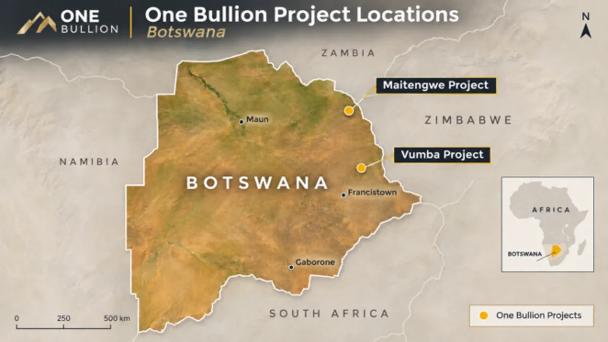
Maitengwe (Fig. 1) is located between Tutume and the Zimbabwe border in northeastern Botswana. Regional geological mapping places the Maitengwe Greenstone Belt within the Francistown Granite–Greenstone Complex of the Archean Zimbabwe Craton. The regional succession includes metamorphosed volcanic and sedimentary rocks, with local mafic–ultramafic assemblages and iron-rich units, intruded by Archean granitoids. In this type of setting, shear zones, lithological contacts, fold-related structures and quartz–carbonate vein systems may be prospective for gold. The local rock types, structures and mineralization styles at individual Maitengwe targets remain to be established by direct observation and sampling. For regional context, the Company's Vumba Project lies to the south-southeast of Maitengwe in northeastern Botswana, and both projects are situated close to the Botswana–Zimbabwe border.
Much of Maitengwe is obscured by transported Kalahari sands, which restrict conventional surface mapping and can reduce the effectiveness of near-surface geochemical methods. The principal exploration challenge is therefore to distinguish bedrock-related features from magnetic effects, primary intrusive contacts, regolith transport and possible processing artifacts, before prioritizing expenditure on drilling.
Figure 1 – Maitengwe in context to Vumba
Results of the 2026 Airborne Program
Xcalibur Smart Mapping acquired the high-resolution magnetic-gradient and radiometric survey from July 7 to July 30, 2026, using a fixed-wing platform. Campbell & Walker Geophysics provided post-processing and preliminary interpretation. One Bullion announced receipt of the final processed dataset on October 14, 2026. The Company is integrating the processed data with historical geophysical, geological, prospecting and geochemical information, subject to verification of original records and spatial control.
Initial interpretation highlights a northeast-trending lithomagnetic framework with several contrasting geophysical domains, including curved magnetic bands in the southwest, a central magnetic trend with compact sources, short lens-like features in the west-central area, an eastern zone of intersecting or discordant trends, and a separately expressed northern banded system. The Company is assessing bends, contacts, terminations and junctions as possible sites for structural investigation. These features could reflect changes in host lithology, intrusions, deformation or a combination of factors; magnetics and radiometrics do not measure gold grade and do not establish the presence of mineralization. The accompanying Figure 2 shows a filtered first-vertical-derivative magnetic product to illustrate the interpreted magnetic fabric; colored raster extent and blank areas should not be equated with legal license boundaries.
Preliminary Target Areas for Field Verification
The Company has identified 32 reconnaissance work areas in nine clusters. Eight areas have been provisionally placed in the first-pass field-assessment group. The prioritization is an internal screening exercise based on the existing geophysical products and geological hypotheses. Field confirmation and Qualified Person review are required before any area is described as drill-ready.
Are local bends or contacts deformed, altered and supported by in-situ gold/pathfinder geochemistry, or do they reflect primary lithology?
Do the margins of magnetic bodies coincide with favorable host contacts or strain zones, rather than unmineralized intrusive margins?
Eastern lens array and discordant body termination
Do intersecting trends represent a meaningful structural junction, or a younger dyke and unrelated magnetic sources?
Can a bend and parallel magnetic contacts be demonstrated in bedrock, and is there reproducible geological and geochemical evidence for prioritized testing?
The list is a framework for testing competing geological interpretations. Neither the number of interpreted features nor their magnetic prominence indicates a corresponding number of gold deposits.
Proposed Staged Exploration Program
Stage 1 — Validate data and assess the ground
Reconcile airborne survey grids and quality control with historical datasets and current license boundaries; conduct focused geological and structural mapping where outcrop is accessible; determine Kalahari cover thickness and the presence of residual regolith; and complete orientation geochemical sampling using appropriate soil, saprolite or bedrock media. The objective is to confirm which geophysical features are geological, whether a sampling method is representative of underlying bedrock and which locations warrant more detailed work.
Stage 2 — Selective trenching and subsurface target definition
Where the cover profile, ground conditions and applicable approvals permit, excavate short, targeted trenches or test windows across verified contacts and structural positions. The purpose is to expose and log lithology, foliation, veining, alteration and possible sulfides and to obtain spatially controlled channel samples. Where transported cover makes surface trenching or soils ineffective, the Company may instead use a suitable shallow subsurface technique to sample the weathered-bedrock interface. The Company is not announcing a blanket trenching commitment; excavation lengths and locations will follow field results and site-specific approvals.
Stage 3 — Conditional RC drilling and follow-up
Advance targets to a staged first-pass RC program only after they demonstrate a defensible combination of geology, structure and appropriately verified geochemistry, or where a tightly scoped geological scout test is justified. Initial holes are expected to focus on the shallow bedrock and interpreted structural geometry, with orientations and depths determined from field results rather than fixed from desktop maps. Follow-up RC, and potentially oriented diamond drilling, would be contingent on geological observations, assay results and the ability to test continuity. No definitive drill-hole count, meterage, mobilization date or exploration budget is being committed in this release.
Technical Objectives and Decision Criteria
The proposed work is designed to (i) identify the rock packages and structures associated with each geophysical feature; (ii) determine whether sampling beneath cover provides meaningful, repeatable gold and pathfinder results; (iii) test the orientation, width and continuity of any mineralized structures indicated by surface or shallow work; and (iv) rank, advance or discontinue targets using explicit technical criteria. Targets that resolve as barren intrusive bodies, transported geochemical responses or unsupported geophysical features will be downgraded rather than drilled solely to complete a planned meterage.
Sampling, Quality Assurance and Environmental Controls
Future field samples will be documented with suitable location, lithological and sampling information. The planned quality-assurance/quality-control program will include appropriate certified reference materials, blanks, duplicates, and custody controls. Analysis will be by independent accredited laboratories using methods suited to the relevant sample media. Details of laboratory methods, sampling intervals, quality-control performance and any material assay results will be disclosed once the work has been completed and reviewed.
Through Premier Gold Resources (Pty) Ltd., the Company received Environmental Impact Statement approval for exploration on PL012/2018 from Botswana's Department of Environmental Protection. The approval is effective April 20, 2026 for two years, subject to applicable mitigation and monitoring requirements. That approval does not by itself authorize for all proposed activities across both Maitengwe licenses. The Company will confirm land access, environmental obligations, site-specific permits and health and safety controls before disturbing ground.
No new Maitengwe gold assay results, mineral resource estimates or mineral reserve estimates are disclosed in this news release. Interpretations of geophysical structures, geological models and priority areas remain preliminary and subject to ground verification. The presence of a magnetic feature, lithological contact or historical selective sample is not evidence of an economically mineralized deposit. The proposed program is exploratory in nature, and there can be no assurance that further work will identify mineralization of economic significance.
Regional Context and Google Earth Views
Figure A. Relative location of the Maitengwe and Vumba projects in northeastern Botswana, shown on a Google Earth base image. The yellow line marks the Botswana–Zimbabwe international boundary visible in the Google Earth view. Company overlays are provided for regional location context only and are not cadastral tenure outlines.
Figure B. Google Earth view of the Maitengwe RTP magnetic image with selected primary and secondary reconnaissance targets overlain. Red-highlighted markers identify first-pass priority targets and orange-highlighted markers identify secondary follow-up targets. Target labels summarize the geological question being tested at each location. This figure is interpretive and does not represent a drill collar plan or verified cadastral mapping.
These Google Earth figures are included to show the relationship of Maitengwe to the Company's Vumba Project and to illustrate how the interpreted target inventory is distributed across the Maitengwe magnetic dataset. They complement, and do not replace, the processed geophysical figures and enlarged target examples set out below.
Selected Figures — Maitengwe 2026 Exploration
Figure 2. Maitengwe 2026 airborne magnetic survey — filtered first vertical derivative of reduced-to-pole magnetics with a 15 m upward-continuation filter (RTP UP15 1VD). Original processed map supplied by Campbell & Walker Geophysics. Colored areas show the extent of the displayed processed product, not verified legal license boundaries; the irregular map edges and white interior gap do not independently establish the limits of survey acquisition or tenure. Magnetic features do not, on their own, establish gold mineralization.
Project-Wide Geophysical Reconnaissance
Figure 3. Preliminary reconnaissance areas plotted on reduced-to-pole magnetic imagery (interpretive raster, not cadastral license mapping). Red points indicate eight priority areas for initial field assessment; amber and blue points represent additional work areas. Colored circles are schematic reconnaissance envelopes, not mineralized extents, drilling approvals or surveyed collar locations. Target ranking is provisional and subject to validation by fieldwork and the Qualified Person.
Examples of Interpreted Structural Tests
Figure 4. Selected enlarged first-vertical-derivative magnetic imagery: (A) the western termination of an ENE-trending magnetic source near T19; and (B) a bend within the northern-cap magnetic system near T23. Both are conceptual geological investigation areas. Magnetic responses may reflect primary lithology, intrusive contacts, remanent magnetization or deformation; the presence of gold mineralization has not been established.
The scientific and technical information in this news release has been reviewed and approved by Tim Raymond, Pr.Sci.Nat., a Qualified Person as defined under National Instrument 43-101 – Standards of Disclosure for Mineral Projects (NI 43-101). Mr Raymond provides independent geological consulting services to the Company through RAYMEX (Pty) Ltd and has conducted site visits to the Vumba Gold Project.
One Bullion Ltd. (TSXV: OBUL) is a Toronto-based gold exploration company focused on advancing high-quality gold assets in Botswana, one of Africa's stable and established mining jurisdictions. Established in 2018, the Company controls approximately 8,004 km² of prospective land across three greenstone belt-hosted gold projects, including Vumba, Kraaipan and Maitengwe. One Bullion's strategy centers on disciplined, data-driven exploration combining modern geological methods with advanced targeting to identify and test high-priority gold targets while maintaining a commitment to environmental stewardship, community engagement and long-term value creation for stakeholders.
This news release contains forward-looking information and forward-looking statements within the meaning of applicable Canadian securities laws. Forward-looking information includes, without limitation, statements regarding geological interpretations, the prospectivity of Maitengwe, the scope, sequence, timing and possible methods of fieldwork, sampling, trenching, shallow subsurface investigations and drilling; intended target ranking and technical objectives; future permitting and access; and potential future exploration results. Such statements are based on management's current assumptions and expectations, including access to funds, equipment, contractors, laboratories and required approvals, and are subject to risks and uncertainties. Actual outcomes may differ materially because of adverse geological results, ineffective sampling media, inaccessible or restricted locations, permitting requirements, contractor or laboratory delays, costs, financing conditions, changes in priorities or other operational and market factors. There can be no assurance that proposed exploration will proceed as contemplated or discover mineralization of economic significance. Readers should not place undue reliance on forward-looking information. Except as required by law, the Company undertakes no obligation to update such information.
Contact Information:Adam Berk, Chief Executive OfficerOneBullion@KCSA.com
Investor Contact:KCSA Strategic CommunicationsJack Perkins or Valter PintoT: 212-896-1254OneBullion@KCSA.com
NEITHER THE TSX VENTURE EXCHANGE NOR ITS REGULATION SERVICES PROVIDER (AS THAT TERM IS DEFINED IN THE POLICIES OF THE TSX VENTURE EXCHANGE) ACCEPTS RESPONSIBILITY FOR THE ADEQUACY OR ACCURACY OF THIS RELEASE.
Photos accompanying this announcement are available at https://www.globenewswire.com/NewsRoom/AttachmentNg/24caaee2-f637-4444-8222-f4144df1a1e1
https://www.globenewswire.com/NewsRoom/AttachmentNg/01b5c9c3-e871-45f6-b9af-bbaeeb5cb21d
https://www.globenewswire.com/NewsRoom/AttachmentNg/3fd44d78-705b-498b-a93a-0d73606ee703
https://www.globenewswire.com/NewsRoom/AttachmentNg/9208c8f7-48ec-499c-be0c-fa2eaa71d2ca
https://www.globenewswire.com/NewsRoom/AttachmentNg/585e1624-688e-4db7-8fda-8b2f94749a65
https://www.globenewswire.com/NewsRoom/AttachmentNg/baae66aa-1233-4d33-87d3-f4a261e5ddfa