The system is arriving in two waves, with the first pushing in late Friday and a stronger follow-up late Saturday. California is getting slammed from all angles as a powerful storm system sweeps across the state, bringing hail, flood risks, heavy mountain snow and even dust concerns for festivalgoers.
Thursday’s wild weather already set the tone, when a severe thunderstorm dumped hail, some as large as pingpong balls, across parts of Northern California, including areas near Modesto, according to the National Weather Service.
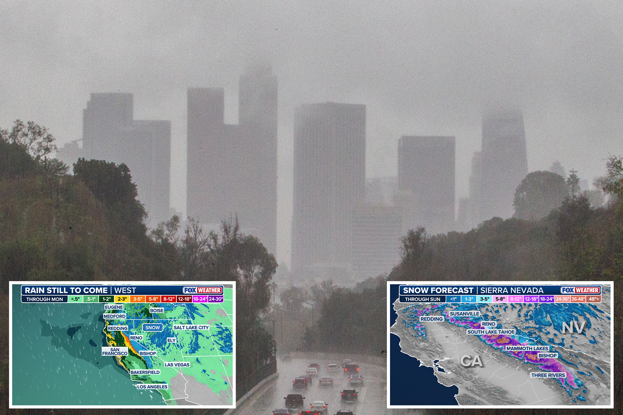
Forecasters say a low-pressure system moving in will deliver widespread rain, mountain snow and possible thunderstorms into Monday.
Rainfall totals are projected to range from 0.50 to 1.50 inches, with higher amounts expected in foothills and mountainous areas, especially where thunderstorms intensify totals.
The system is arriving in two waves, with the first pushing in late Friday and a stronger follow-up late Saturday.
One social media user wrote: “I hope the rain and thunderstorms miss us this weekend! I don’t want it to come!”
The CBS News Sacramento First Alert Weather team warns that multiple squall lines are expected to surge inland Saturday evening, raising the chance of heavy downpours, poor drainage, localized flooding and strong thunderstorms across the Sacramento Valley and surrounding areas.
In the San Francisco Bay Area, the same system is expected to bring gusty winds and up to three-quarters of an inch of rain by Saturday night, with thunderstorm chances increasing late Saturday and peaking early Sunday as the storm’s core tracks east.
According to Fox 5 San Diego, rain returns to San Diego County through Saturday with scattered showers, a slight chance of thunderstorms and noticeably colder conditions, especially in the mountains, where temperatures could dip 10 to 15 degrees below normal.
Lingering showers and gusty winds may continue into Sunday.
CBS LA has issued a “Next Weather Alert” through Sunday as rain and possible thunderstorms move across the Los Angeles area, with additional showers pushing south through the region Sunday.
Meanwhile, drivers along the Grapevine could even see a light dusting of snow late Sunday into early Monday, with forecasters putting the chance at 10–20%.
Up in the Sierra, the storm is expected to deliver a major late-season boost.
According to the National Weather Service and Powder forecasts, snow begins Friday evening with a warmer first wave before intensifying Saturday night into Sunday as colder air drops snow levels from around 7,000–7,500 feet to roughly 3,500–4,500 feet.
The most reliable window for snowfall runs from Friday afternoon through Monday afternoon.
Projected totals are highest at Kirkwood, with 19 to 29 inches expected by Monday.
Palisades Tahoe could see 13 to 20 inches, Mammoth Mountain 11 to 17 inches, and Mt. Rose around 6 to 8 inches, though Mt. Rose is expected to take the brunt of strong winds.
Sunday is shaping up as the prime day for conditions statewide, with Mammoth offering the best snow quality and Kirkwood delivering the deepest accumulation.
Music fans heading to the Coachella Valley Music and Arts Festival are being warned about hazardous conditions as strong winds and possible rain sweep through the area.
An air-quality alert is in effect for the Coachella Valley, where gusts up to 35 mph on Friday and Saturday could kick up large amounts of dust, sending particulate matter known as PM10 into the air and creating unhealthy breathing conditions.
From hail to snow to dust, the Golden State is in for a turbulent, weather-whiplash.nd