Lavras Gold Defines a District-Scale Gold-in-Soil Corridor at Lavras do Sul and Identifies Cerrito North as a New Exploration Target TMX Newsfile Tue, October 13, 2026 at 7:00 AM EDT 20 min read LGC.V +3.00% GC=F +0.40% LGCFF -0.84% E1R0.F -3.76% Independent re-processing of the Company's soil geochemistry defines a district-scale corridor linking Fazenda-Butia, Caneleira and Cerrito North along a mapped intrusive contact, while drill core geochemistry and geophysics support the broader geological interpretation; the work also expands the geochemical footprint at Matilde and identifies Cerrito North as a new exploration target
Toronto, Ontario--(Newsfile Corp. - October 13, 2026) - Lavras Gold Corp. (TSXV: LGC) (OTCQX: LGCFF) ("Lavras Gold" or the "Company") today reports the results of an independent geochemical interpretation of its Lavras do Sul Project ("LDS Project" or the "Project") in Rio Grande do Sul, Brazil, and introduces Cerrito North as a new exploration target. The interpretation was subsequently completed by the independent consulting geochemist who participated in the Company's specialist technical workshop held in April 2026 (see news release dated May 12, 2026). It integrates the Company's soil geochemistry, drill core multielement assays, whole-rock lithogeochemistry and airborne geophysics into a single district-scale framework.
Cerrito North is a new target, identified on the northern continuation of the Caneleira trend. No assay results have been received from Cerrito North and no mineral resource has been estimated there.
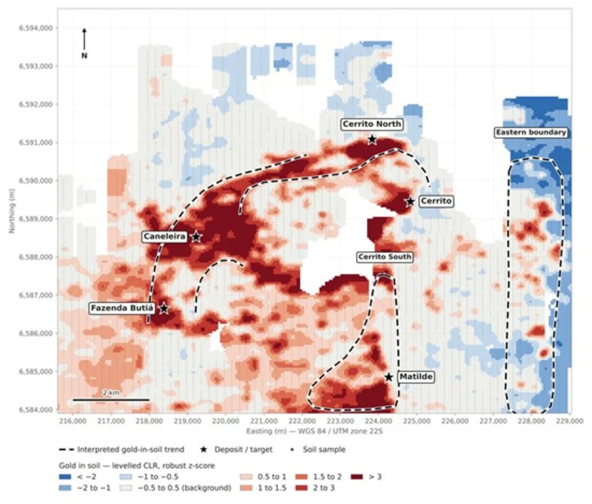
An independent re-processing and statistical levelling of the Company's historical and current soil and drill core multielement geochemistry has defined a continuous gold-in-soil corridor of approximately 10 kilometres ("km") measured along trend — approximately 7km in a straight line — linking Fazenda-Butia, Caneleira and Cerrito North (Figure 1).
The corridor follows the contact between an internal geochemical halo (Sr-Ba-Ca-P-Mg; granodiorite signature) and an external geochemical halo (Ga-Th-U-Zn-V-Fe; evolved potassium-rich granite signature). The same boundary is independently expressed in the Company's gamma-ray spectrometry data.
Two mineralized geochemical associations are recognized across the district:
Au-Cu-Bi-Ag, linked to granodiorite-related rocks - higher-temperature and more deeply rooted; best expressed at Matilde; and
Au-Pb-Zn-As, linked to potassium-rich granite and episyenite-style alteration - a shallower, structurally controlled overprint; best expressed at Fazenda-Butia.
Zones where the two systems overlap carry Au-Ag-Bi-W-Cu with As-Sb-Mo and are interpreted as late, structurally confined corridors. These overlap zones are the Company's principal new criterion for ranking and generating targets.
At Matilde, the gold-in-soil anomaly extends north and south beyond the drilled footprint of approximately 500 metres ("m") by 400m. Historical drilling approximately 300m to the south returned low-grade gold open at the end of hole, with molybdenum increasing at the end of hole. Copper is also anomalous in soil at Matilde, coincident with and extending the gold anomaly, and a separate copper-molybdenum cluster is present to the north-northeast.
Two further trends warrant follow-up: the north-south Matilde-Cerrito South trend, and an eastern boundary trend along the structurally controlled margin of the complex, which includes the Aurora and Dourada occurrences and a discrete As-Sb zone.
Soil geochemical anomalies are exploration indicators only. They do not demonstrate the presence of mineralization, are not mineral resources, and there is no certainty that any target described in this release will result in the definition of a mineral resource.
The interpretation supports the view that the gold occurrences at Lavras do Sul are the preserved expression of one larger mineralizing system rather than a series of separate deposits, and it changes how the Company ranks and generates targets across its approximately 20,300-hectare tenement package. Cerrito North is the first new target to be identified from this framework.
Figure 1 - Levelled gold-in-soil residuals across the central LDS Project, showing the interpreted gold-in-soil corridor linking Fazenda-Butia, Caneleira and Cerrito North, together with the Matilde-Cerrito South and eastern boundary trends. Interpreted trends are drawn from the distribution of levelled soil values and are conceptual; they are not mineralized boundaries.
To view an enhanced version of this graphic, please visit:https://images.newsfilecorp.com/files/10429/318657_4bbc18bfd45209b4_002full.jpg
"This work fundamentally changes how we see the opportunity at Lavras do Sul: not as a collection of individual gold deposits and targets, but as the preserved expression of a potentially much larger mineralizing system," commented Federico Velásquez, President and Chief Executive Officer. "The soil geochemistry defines a compelling district-scale corridor along a mapped intrusive contact-independently confirmed by geophysics and aligned with known mineralized areas. This gives us a powerful new framework to unlock value across the district. We are no longer asking only how large each deposit may become; we are systematically identifying where else along these prospective trends the system may have concentrated gold. Cerrito North may be the first of several opportunities to emerge from this approach."
"The value of this interpretation is that it is built on our existing data," added Jonathan Hill, Director and Interim Vice President of Exploration. "Much of the data had never been levelled and analyzed together, because they were collected over many years by different operators, laboratories and analytical methods. Once that was corrected for, coherent geochemical domains appeared that match what we see in drill core and in the geophysics. It gives us an objective basis for ranking targets rather than relying on one conceptual model across the whole district."
Cerrito North is a soil geochemical target on the northern continuation of the Caneleira trend, where the levelled gold-in-soil data define a discrete anomaly accompanied by silver, potassium and sulphur responses consistent with the alteration signature recognized elsewhere in the district.
The soil data covering the target combine two analytical methods — 186 samples by aqua regia digestion with an ICP finish, and 1,026 samples by fire assay with an AAS finish — and the levelling of the residualized values in this area requires recalibration before the anomaly can be considered fully validated. Cerrito North is disclosed as an exploration target concept derived from surface geochemistry. It is not a mineral resource, and there is no certainty that drilling will result in the definition of a mineral resource.
Figure 2 - Levelled gold and pathfinder element soil residuals over the Cerrito North area, showing the suggested target outline and its position on the northern continuation of the Caneleira trend. The levelling of the residualized values in this area requires recalibration, and the outline shown is conceptual.
To view an enhanced version of this graphic, please visit:https://images.newsfilecorp.com/files/10429/318657_4bbc18bfd45209b4_003full.jpg
A District-Scale Geochemical Footprint
Soil geochemistry has been collected over the LDS intrusive complex in several campaigns since 2009 by the Company and by previous operators, using more than one sample preparation and analytical method. Because those methods are not directly comparable for many elements, the datasets were statistically levelled and transformed before interpretation, and analytical methods were kept separate where levelling could not be reliably established. Recent reprocessing activities found:
The gold-in-soil data define a coherent arc rather than a set of isolated anomalies.
The arc extends approximately 10km along trend - approximately 7km in a straight line - from Fazenda-Butia in the southwest, through Caneleira, to Cerrito North. The Cerrito deposit lies on the eastern portion of the same feature.
The corridor is an interpretation drawn from the distribution of levelled soil values; its limits have not been defined by a fixed geochemical threshold.
Figure 3 - Levelled multielement heat maps for the merged soil and drill core dataset across the LDS Project. Gold and its pathfinder elements are shown together with the lithological discriminants used to separate the granodiorite-related and potassium-rich granite-related domains. Values are levelled compositional residuals and are not absolute concentrations.
To view an enhanced version of this graphic, please visit:https://images.newsfilecorp.com/files/10429/318657_4bbc18bfd45209b4_004full.jpg
Geochemical Signature and Relationship to Mineralization
The Au-Cu-Bi-Ag association is linked to granodiorite-related rocks, which carry elevated strontium, weak europium depletion and a mantle-influenced signature. These are interpreted as the higher-temperature and more fertile magmatic component of the system. The association is dominant at Matilde, interpreted to expose a deeper or more proximal part of that system.
The Au-Pb-Zn-As association is linked to potassium-rich granites and episyenite-style alteration emplaced at the structurally controlled margins of the complex, and is interpreted as a shallower, later overprint that remobilized gold into more permeable structural sites. It is dominant at Fazenda-Butia, where both signatures are present and overlap.
Spatially, the two associations define a concentric zonation: an internal halo (Sr-Ba-Ca-P-Mg) corresponding to the granodiorite signature, and an external halo (Ga-Th-U-Zn-V-Fe) corresponding to the younger potassium-rich granite signature at the structurally controlled borders of the dome.
Both halos coincide with the corresponding responses in the Company's gamma-ray spectrometry survey — an independent indication that the zonation reflects geology rather than an artefact of the sampling or analytical history.
Thorium and uranium are reported here solely as lithogeochemical discriminants of the evolved potassium-rich granite phase, in which enrichment in these elements is a normal and expected characteristic. The values shown are levelled compositional residuals, not absolute concentrations. The Company is not exploring for uranium and no uranium anomaly is reported in this release.
Figure 4 - Soil geochemical classification of the LDS intrusive complex showing the internal halo (granodiorite signature) and the external halo (evolved potassium-rich granite signature) at the structurally controlled margins of the dome. The interpreted gold corridor shown in Figure 1 follows the contact between the two.
To view an enhanced version of this graphic, please visit:https://images.newsfilecorp.com/files/10429/318657_4bbc18bfd45209b4_005full.jpg
Zones in which the granodiorite-related and potassium-rich granite-related signatures overlap carry Au-Ag-Bi-W-Cu together with As-Sb-Mo, and are interpreted as late, shallow alteration confined to shear and fault structures. These overlap corridors — rather than individual vein occurrences — are now the Company's primary surface targeting criterion.
Mapped on this basis, the soil data highlight Caneleira, Matilde, and the Aurora and Dourada occurrences on the eastern margin of the complex, together with a discrete As-Sb zone in the same eastern domain.
Matilde is the clearest expression of the granodiorite-related Au-Cu-Bi-Ag association at the Project. Historical drilling has defined a mineralized footprint of approximately 500m by 400m, and the gold-in-soil anomaly extends both north and south beyond it.
Historical drill holes collared approximately 300m south of the known mineralization at Matilde returned low-grade gold that remains open at the end of hole, with molybdenum increasing at the end of hole. Copper is anomalous in soil in the southeast of the Matilde area, coincident with and widening the gold anomaly, and chalcopyrite has been logged in the hydrothermally altered zones in drill core. A separate cluster of threshold-level molybdenum with associated copper is present to the north-northeast.
Elevated copper and molybdenum are recognized vectors toward the higher-temperature parts of intrusion-related systems. No mineral resource has been estimated at Matilde.
Figure 5 - Soil geochemical domains across the LDS Project with the principal target areas annotated. Areas where the granodiorite-related and potassium-rich granite-related signatures overlap are interpreted as the most prospective zones for follow-up.
To view an enhanced version of this graphic, please visit:https://images.newsfilecorp.com/files/10429/318657_4bbc18bfd45209b4_006full.jpg
Methodology and Data Verification
The soil database comprises 24,371 samples collected between 2009 and 2026 by the Company and by previous operators. Sample preparation, digestion and analytical finishes are not uniform: earlier campaigns were analysed for 35 elements by ICP, later campaigns for 55 elements, and the Cerrito North area combines aqua regia and fire assay datasets.
All multielement data were centred-log-ratio transformed and statistically levelled before interpretation. Datasets generated by non-equivalent digestion methods were evaluated separately where levelling could not be reliably established.
The values shown in the figures are levelled compositional residuals — relative gold and pathfinder enrichment — and are not absolute concentrations in parts per billion or parts per million.
The soil geochemical database used in this interpretation comprises 24,371 samples collected between 2009 and 2026 by the Company and by previous operators of the Project. The samples were analysed by three laboratories under different preparation and analytical protocols: ACME (12,450 samples, 2009 to 2012), ALS (1,531 samples, 2009 to 2019) and SGS GEOSOL (10,390 samples, 2020 to date). Quality control samples comprising 169 certified reference materials, 61 blanks and 4 field duplicates are present in the database, inserted at approximately 0.1% to 0.2% of samples in the campaigns completed before 2020 and at approximately 2% of samples in those submitted to SGS GEOSOL.
The Qualified Person has reviewed the structure and completeness of the database, the distribution of samples by laboratory, analytical method and target area, and the certified reference material and blank results available for the campaigns analysed by SGS GEOSOL.
The Qualified Person notes the following limitations of the historical data. Sample dates are absent or inconsistently recorded for a substantial proportion of the database, including all of the quality control samples, so the date field alone is not sufficient to assign samples to a campaign. Quality control insertion rates in the campaigns completed before 2020 were materially below current practice. The analytical methods used across the campaigns are not directly equivalent for all elements, which is the reason the data were statistically levelled, and compared only within comparable method groups, before interpretation.
Having regard to these limitations, the Qualified Person considers the soil geochemical database to be adequate for the generation, ranking and prioritization of the exploration targets described in this release. The database has not been verified to a standard that would support the estimation of mineral resources, and no mineral resource has been estimated from it.
Near-term exploration remains concentrated on the consolidated Caneleira Target, where an approximately 25,000m diamond drilling programme is in progress (see news release dated September 14, 2026).
Recalibration of the levelling of the Cerrito North soil dataset is in progress.
An infill soil programme is planned over the priority overlap corridors identified by this work, and the geochemical framework will be used to sequence targets for drill testing through 2027.
Advancing the Fazenda-Butia development project through permitting remains the Company's core development focus and is unaffected by the exploration work described in this release.
Jonathan Hill, Director and Interim Vice President of Exploration for Lavras Gold Corp., is the "Qualified Person" as defined under National Instrument 43-101, Standards of Disclosure for Mineral Projects, and has reviewed and approved the technical information contained in this release.
Quality Assurance & Quality Control: Sample handling, preparation, and analysis are monitored through the implementation of formal chain-of-custody procedures and quality assurance/quality control programs designed to follow industry best practices.
Soil samples referred to in this release were collected from the B soil horizon on lines spaced 200 metres apart with samples at 25 metre intervals, tightening to a 50 by 50 metre grid in infill areas, with waterlogged ground avoided. Samples have been analysed by three laboratories over the life of the database: ACME (2009 to 2012), ALS (2009 to 2019) and SGS GEOSOL Laboratórios S.A. of Vespasiano, Minas Gerais State, Brazil (2020 to date), the latter accredited to ISO/IEC 17025:2017. At SGS, samples are dried, disaggregated and screened to 80 mesh and 300g of the passing fraction is pulverized to 95% passing 150 mesh; gold is determined by 30g fire assay with an AAS finish and a further 42 elements by multi-acid digestion with an ICP-OES/ICP-MS finish.
Certified reference materials and blanks are inserted into the soil sample stream. Insertion rates vary over the life of the database, from approximately 0.1% to 0.2% of samples in the campaigns completed before 2020 to approximately 2% of samples submitted to SGS. Results are evaluated for accuracy, precision and contamination. Soil results are used by the Company as a targeting tool and are not used in the estimation of mineral resources.
Soil geochemical sampling is a surface exploration technique. Soil anomalies reflect the dispersion of elements in the weathering environment and may be displaced from, or unrelated to, bedrock mineralization. Gold dispersion at the LDS Project is further affected by seasonal water table movement, which can concentrate gold at preferential horizons within the soil profile. Soil results are therefore not a substitute for drilling.
Drill core multielement data referred to in this release were generated from split NQ diamond drill core logged and sampled in a secure facility located in Lavras do Sul, Rio Grande do Sul State, Brazil, and analysed by ALS Laboratories Inc. Certified standards, non-certified blanks and field duplicates are inserted into the drill core sample stream at regular intervals, so that QA/QC accounted for about 10% of the total samples. Results are routinely evaluated for accuracy, precision, and contamination.
The LDS Project is centred on the town of Lavras do Sul in Rio Grande do Sul, Brazil. It is approximately 320 kilometres, or a 4.5-hour drive, from the state capital of Porto Alegre. The Company, through its subsidiary, holds, directly or indirectly, contractual interests over 31 mineral rights covering approximately 20,300 hectares.
The LDS intrusive complex is a multiphase intrusive centre surrounded by coeval volcanic rocks to the east. Geologically, LDS lies in the far south of the Neoproterozoic Mantiqueira Province, a 2,700-kilometre-long belt of tectonically and magmatically accreted terrains stretching as far south as the coastline of central Uruguay and north into southern Bahia State in Brazil. The most advanced targets are the Fazenda-Butia and Cerrito gold deposits. Fazenda-Butia hosts Measured mineral resources of 4.6 million tonnes grading 0.88 g/t gold containing 132,000 ounces of gold and Indicated mineral resources of 8.3 million tonnes grading 0.92 g/t gold containing 246,000 ounces of gold (total Measured and Indicated mineral resources of 12.9 million tonnes grading 0.91 g/t gold containing 377,000 ounces of gold) and Inferred mineral resources of 3.7 million tonnes grading 0.97 g/t gold containing 115,000 ounces of gold. Cerrito hosts Indicated mineral resources of 8.3 million tonnes grading 0.70 g/t gold containing 188,000 ounces of gold and Inferred mineral resources of 13.2 million tonnes grading 0.69 g/t gold containing 293,000 ounces of gold. Mineral resources are reported at a gold cut-off grade of 0.30 g/t. Numbers may not sum due to rounding. Mineral resources are not mineral reserves and do not have demonstrated economic viability. No mineral resources have been estimated at Caneleira, Cerrito North or Matilde.
1. NI 43-101 Technical Report Mineral Resource for the Butia Gold Prospect, Rio Grande do Sul, Brasil. Prepared by VMG Consultoria e Soluções Ltda., effective date January 25, 2022, amended report date November 15, 2024.
2. NI 43-101 Technical Report Mineral Resource for the Cerrito Gold Prospect, Rio Grande do Sul, Brasil. Prepared by VMG Consultoria e Soluções Ltda., effective date May 31, 2022, amended report date November 15, 2024. These reports are available on the Company's website and at www.sedarplus.ca under Lavras Gold's issuer profile.
Lavras Gold Corp. is a Canadian exploration company focused on realizing the potential of its LDS Project situated in a highly prospective gold district in southern Brazil. The LDS Project is located near the town of Lavras do Sul in Rio Grande do Sul State, Brazil, and is primarily an intrusive-hosted gold system of possible alkaline affinity. More than 24 gold prospects centred on historic gold workings have been identified on the LDS Project properties, which span approximately 20,300 hectares. For more information on Lavras Gold visit www.lavrasgold.com.
Federico Velásquez, President & Chief Executive Officer
Disclaimer: Neither TSX Venture Exchange nor its Regulation Services Provider (as that term is defined in the policies of the TSX Venture Exchange) accepts responsibility for the adequacy or accuracy of this release.
Forward-looking statements: This news release includes certain "forward-looking information" within the meaning of Canadian securities legislation and "forward-looking statements" within the meaning of the United States Private Securities Litigation Reform Act of 1995 (collectively "forward-looking statements"). Forward-looking information in this news release includes, but is not limited to: statements regarding the interpretation of the Company's soil and drill core geochemistry, including the existence, extent, continuity and significance of the interpreted gold-in-soil corridor and of the Matilde-Cerrito South and eastern boundary trends; the interpreted relationship between geochemical associations, hydrothermal alteration and gold mineralization; the prospectivity of the Cerrito North, Matilde, Aurora and Dourada target areas and the expectation that they warrant follow-up or drill testing; the planned recalibration of the levelling of the Cerrito North soil dataset; the planned infill soil programme; the commencement, scope, sequencing and duration of drilling at the Caneleira Target; and the advancement and permitting of Fazenda-Butia.
Forward-looking statements are often, but not always, identified by the use of words such as "seek", "anticipate", "believe", "plan", "estimate", "forecast", "expect", "potential", "project", "target", "schedule", "budget" and "intend" and statements that an event or result "may", "will", "should", "could" or "might" occur or be achieved and other similar expressions and includes the negatives thereof. All statements other than statements of historical fact included in this release are forward-looking statements that involve various risks and uncertainties. Forward-looking information is based on management's current expectations and assumptions, including assumptions regarding the reliability and comparability of historical geochemical data generated by previous operators and by different laboratories and analytical methods, the validity of the statistical levelling applied to that data, exploration results, geological continuity, the availability of drill rigs, personnel and equipment, field and weather conditions, laboratory turnaround times, regulatory approvals, financing, commodity prices and the Company's ability to execute its exploration and development plans.
Actual results may differ materially as a result of exploration risk, the possibility that further work does not confirm current geological or geochemical interpretations, the risk that soil geochemical, geophysical and grab sample results do not reflect the presence of economically recoverable mineralization, changes in project parameters as plans continue to be refined, results of future mineral resource estimates and technical studies, availability and cost of capital, changes in commodity prices, delays in laboratory results or regulatory approvals, title risks, environmental risks and other risks described in the Company's continuous disclosure filings. Although the Company has attempted to identify important factors that could cause actual actions, events or results to differ from those described in forward-looking statements, there may be other factors that cause such actions, events or results to differ materially from those anticipated. There can be no assurance that forward-looking statements will prove to be accurate and accordingly readers are cautioned not to place undue reliance on forward-looking statements. Except as required by applicable securities laws, the Company undertakes no obligation to update such information.
To view the source version of this press release, please visit https://www.newsfilecorp.com/release/318657