Stardust Identifies High-Grade Gold West of the Amikougami Fault, Adjacent to Agnico Eagle's Macassa Mine TMX Newsfile Tue, October 13, 2026 at 6:00 AM EDT 15 min read GC=F +0.47% AEM -0.44% ZIGY.V +3.85% Trade AEM on Coinbase Trading disclosure Trading disclosure The above button links to Coinbase. Yahoo Finance is not a broker-dealer or investment adviser and does not offer securities or cryptocurrencies for sale or facilitate trading. Coinbase pays us for certain activity generated through this link. Prices displayed are informational.
High-grade gold on the west side of the fault, from surface to more than 700 vertical depth: historic production at the Baldwin Mine (~18 g/t gold recovered), a 1938 drill hole (S-6) that reported spectacular free gold, and the Company's 2021 hole BAL21-024, which returned 86.2 g/t gold over 0.5 meters with visible gold at ~923 meters downhole.
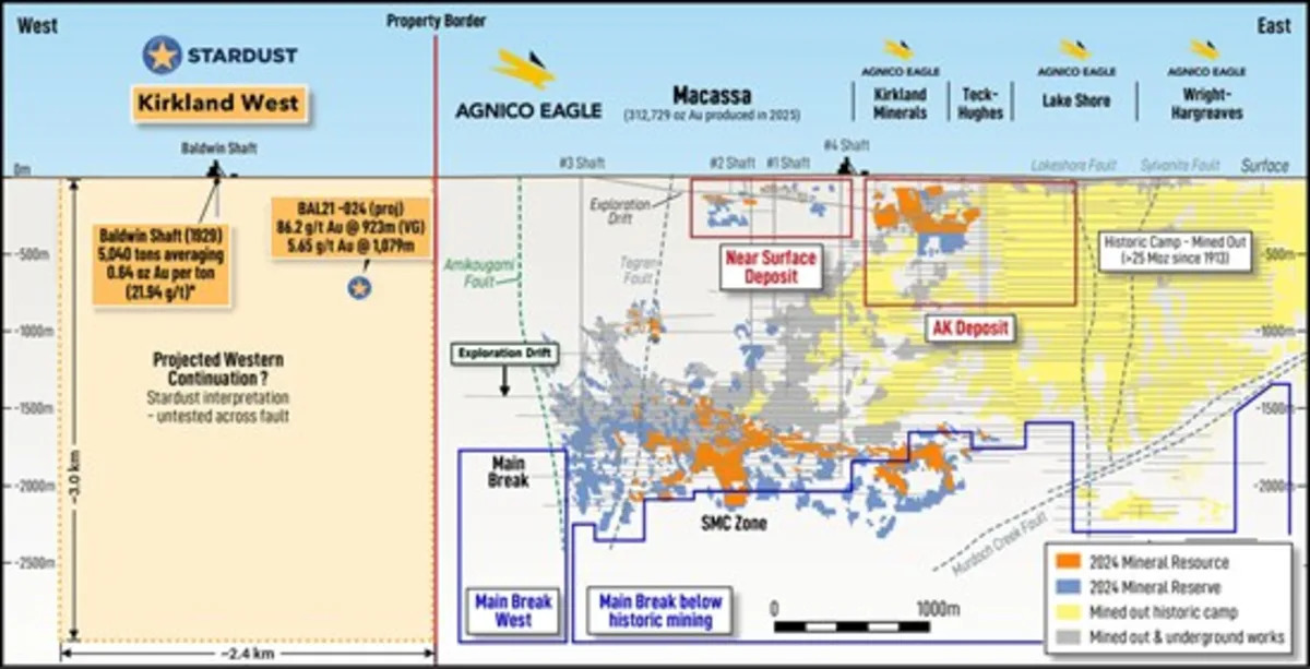
Agnico Eagle's Macassa section points west: Agnico Eagle's published longitudinal section shows Macassa's reserves and resources trending west toward the Amikougami Fault, with a "Main Break West" exploration target drawn to the Kirkland West property boundary.
Amikougami is Offset, not ended: Stardust interprets the Amikougami Fault as post-mineral, with the camp's Main, Amalgamated and Cadillac-Larder Lake breaks displaced across it and continuing onto Kirkland West, where they are interpreted to converge.
Historical Hole S-6: intersected the Baldwin vein at ~70 m depth, with free gold reported over 9 feet (2.74m) interval. Drilling beneath the historical workings in 2020 intersected lithologies favorable for gold mineralization, and the target remains open. Follow-up exploration has been limited, making this a priority near-surface exploration target.
Under-explored and moving to drilling: the Baldwin veins remain potently open at depth, and 2026 fieldwork is underway, with a primary focus on detailed mapping around the Baldwin shaft and the Cadillac Break. Drill permitting is underway, with LiDAR, IP and deep electromagnetic surveys planned ahead of a two-tier drill program.
Beyond Kirkland West, Stardust will shortly outline a comprehensive exploration and development plan for its McGarry and Omega Projects, detailing planned drilling, resource updates, infrastructure initiatives and other key milestones.
Toronto, Ontario--(Newsfile Corp. - October 13, 2026) - Stardust Metal Corp. (TSXV: ZIGY) ("Stardust" or the "Company") is pleased to set out the evidence for high-grade gold at its 100%-owned Kirkland West Project ("Kirkland West" or the "Project"). The Project shares a property boundary with Agnico Eagle Mines Limited's ("Agnico Eagle") Macassa Mine on the western edge of the Kirkland Lake gold camp in Ontario. (Figure 1)
The Kirkland Lake camp has produced more than 25 million ounces of gold since 1913, almost all of it from a seven-kilometer corridor east of the north-south Amikougami Fault. Because the camp's familiar geology does not simply continue across the fault, the ground to the west has received only a fraction of the deep drilling applied to the historic camp. The question at Kirkland West has never been whether gold exists west of the fault. The Baldwin Mine settled that a century ago. The question is where the camp's ore-controlling structures re-emerge after displacement.
"Kirkland West is not simply a proximity story, we have a historic producing mine, a 1938 drill hole that intersected bonanza-grade gold, and our own drilling that returned 86.2 g/t gold. These are compelling indications of high-grade mineralization west of the Amikougami Fault, an area that has seen remarkably little modern exploration.
"For nearly a century, the fault was treated as the western limit of the Kirkland Lake gold camp. We believe it may have displaced the gold-bearing structures rather than terminated them. By integrating the schematic historic mine plans, our drilling results and Agnico Eagle's longitudinal section (Figure 2), we are looking to reconstruct a geological system that may extend well beyond its historically understood boundaries. Agnico Eagle's work further supports our interpretation, with its western exploration targets trending toward our property. Our objective is straightforward: establish the geological continuity, systematically drill the highest-priority targets and determine the scale of what we believe could be a significant, overlooked high-grade gold opportunity in one of Canada's most prolific gold camps," said Stephen Stewart, Chairman of Stardust.
View All Figures from Stardust's Kirkland West Release
Figure 2: Longitudinal section (looking north) of the Macassa Mine, adapted from Agnico Eagle's public disclosure of year-end 2024 mineral reserves and resources, with the Kirkland West boundary, Baldwin shaft and projected location of BAL21-024 added by Stardust. The "Projected Western Continuation" is Stardust's interpretation and is untested. Mineralization at Macassa is not necessarily indicative of mineralization on Kirkland West.
To view an enhanced version of this graphic, please visit:https://images.newsfilecorp.com/files/2809/318636_1650c2fee495f996_002full.jpg
What Is Known: Four Data Points West of the Amikougami Fault1. The historic Baldwin Mine. Gold was discovered on the property in 1911. Between 1917 and 1934, operators sank a shaft to ~127 meters, developed four levels and completed ~1,177 meters of lateral development. Ontario government records (MDI42A01SE00093)1 report 81 tons milled for 43 ounces of gold (0.53 oz/ton, ~18 g/t) and a historical estimate of 5,040 tons averaging 0.64 oz/ton (~21.9 g/t) between the 200- and 300-foot levels. Mineralization consists of narrow, high-grade quartz-carbonate veins in altered syenite and porphyry, the same association as the Kirkland Lake mines. Stardust has georeferenced the historic schematic level plans2 into its 3D model. The mapped veins remain open along strike and down-plunge and have seen only limited modern drill testing along strike and at depth around the Baldwin shaft (Figure 3, Figure 4, and Figure 5).
2. Historic hole S-6 (1938): high grade found beyond a fault. Lucky-Kirkland Gold Mines drilled hole S-6 from surface (Figure 4) to find the Baldwin vein system beyond a fault that had cut off the ore on the 300-foot level (Lev-3). As reported in The Northern Miner (May 1938)3, the hole cut 11 feet of vein at ~70 meters vertical depth and noted "spectacular free gold" over a 9-foot section, with an assay of $2,118.90 per ton at that point (Figure 6). At the gold price of the day (~US$35/oz), that is roughly 60 oz/ton (Company calculation; sample basis not recorded). S-6 matters for two reasons: it is an independent record of bonanza-grade gold at shallow depth outside the mined ore shoot, and it showed, at mine scale, exactly what Stardust interprets at property scale: gold structures at Kirkland West are offset by faulting, not ended by it (Figure 3 and Figure 4). To the Company's knowledge, given the nature of the mineralization, S-6 has been tested by only limited, widely spaced drilling along strike and at depth and remains a priority exploration target (Figure 4).
3. Modern drilling (2021-2022): 86.2 g/t gold at depth. While Kirkland Lake Gold Ltd. (now part of Agnico Eagle) held an option on the property, the Company (then Mistango River Resources Inc.) drilled seven holes (~5,400 meters) in the Baldwin Zone west of the fault4:
BAL21-024: Intersected 86.2 g/t gold over 0.5 meters from 922.81 meters downhole (metallic screen; visible gold in a sheared quartz-carbonate vein), and 5.65 g/t gold over 0.97 meters from 1,079.15 meters downhole. Both were interpreted at the time to be associated with the Main Break and/or Amalgamated Fault, the structures that control mineralization at Macassa.
BAL22-025: 1.09 g/t gold over 1.0 meter from 716 meters downhole, ~150 meters above the BAL21-024 intercept.
BAL21-021: 1.13 g/t gold over 3.0 meters from 225 meters downhole.
Together these holes intersected gold, including visible gold in BAL21-024, across ~750 vertical meters within one structural corridor, inside broad potassic-hematite ("brick-red" syenite) alteration that the Company interprets as a kilometer-scale hydrothermal system. To the Company's knowledge, BAL21-024 is the deepest hole drilled west of the fault. It found high-grade gold at the depths where Macassa's reserves and resources are defined (Figure 2).
4. 2026 field work and a broader pattern. Company mapping along the Cadillac-Larder Lake corridor is underway, with a primary focus on detailed mapping around the Baldwin shaft and the Cadillac Break. Historical mine waste rock observed around the Baldwin shaft is dominated by potassic-hematite-altered syenite containing quartz stringers. Historical drilling at the Eby Zone5, approximately 3 km southwest of Baldwin, together with several historical shafts and mineral occurrences along the corridor, extends the pattern of gold mineralization west of the fault beyond a single locality.
Agnico Eagle's Macassa Section Points to Kirkland WestAgnico Eagle's published longitudinal section of Macassa (year-end 2024 reserves and resources), reproduced in Figure 2 above with Stardust's data added, shows the SMC Zone and Main Break mineralization extending west and down toward the Amikougami Fault at ~1,000 to 2,000 meters depth. It shows an exploration drift advancing west at depth and a "Main Break West" exploration target drawn across the fault to the Kirkland West boundary. Agnico Eagle's section stops at that boundary and makes no interpretation of Stardust's ground. In Stardust's interpretation (Figure3), the westward trend, continued across the fault, projects onto Kirkland West at depth near the BAL21-024 intercept. That ground has not been drilled. Figure 2.
The Interpretation: Offset, Not TerminationThe following is the Company's interpretation and has not been confirmed by drilling. The Amikougami Fault is a late structure that the Company interprets to post-date gold. On that view, it displaced the camp's gold-bearing breaks rather than ending them. The Cadillac-Larder Lake and Amalgamated breaks are mapped on both sides of the fault; the Baldwin veins sit north of the Cadillac-Larder Lake Break in the same position the Kirkland Lake mines occupy to the east; and Stardust's 3D reconstruction, using Macassa's published architecture as a prototype, places the Main, Amalgamated and Cadillac-Larder Lake breaks converging on Kirkland West (Figure 3). At Macassa, the best grades occur where the breaks intersect and branch. If the interpretation is correct, Kirkland West hosts the same ore-controlling setting that made the camp, displaced west and largely untested.
81 tons for 43 oz (~18 g/t); estimate of 5,040 tons at 0.64 oz/ton (~21.9 g/t)
Historical; not verified by a QP; not a current resource
11 ft of vein; "spectacular free gold" over 9 ft; assay $2,118.90/ton (~60 oz/ton)
86.2 g/t Au over 0.5 m (VG); 5.65 g/t Au over 0.97 m
1.09 g/t Au over 1.0 m; 1.13 g/t Au over 3.0 m; VG at ~326 m
Main Break and SMC trend west; "Main Break West" target drawn to the property boundary
Third-party disclosure; relevance is Stardust's interpretation
Strategic Ground on the Western Edge of the CampKirkland West covers ~4,790 hectares, including claims recently staked west of the Amikougami Fault, along the Cadillac-Larder Lake Break. Its eastern boundary adjoins Macassa. The structural corridor continues west toward Alamos Gold's Young-Davidson Mine, and Barrick Mining Corporation has recently staked ground farther west. Together with the Company's Omega and McGarry projects to the east on the same break, Kirkland West gives Stardust a district-scale position in the camp.
Drill permitting is underway. Over the coming months the Company plans to:
Survey: LiDAR over the Baldwin and Eby areas; ground IP, including 3D inversion of historical IP data south of Highway 66; and a deep-penetrating VTEM or magnetotelluric survey to trace the breaks at depth.
Model: complete the integrated 3D model, incorporating the Baldwin workings, S-6, all drilling, geophysics and the regional structural framework.
Drill: a two-tier program. Shallow holes will follow up the Baldwin veins and S-6, and deep holes will follow up BAL21-024 along the interpreted westward projection of the Main Break, Amalgamated Break and SMC trend.
Historical Information and Cautionary NotesHistorical information in this news release, including Baldwin Mine production and development, the historical estimate, the 1938 S-6 result and historical Eby Zone drilling, is derived from Ontario government records (including Ontario Mineral Deposit Inventory record MDI42A01SE00093), historical reports and, for S-6, a contemporary report in The Northern Miner (May 1938, reprinted May 2, 1988). This information predates NI 43-101, has not been verified by a Qualified Person and should not be relied upon. Original assay certificates for S-6 have not been located; the assay is expressed in 1938 dollars per ton, the sample basis is not recorded, true width is unknown, and the conversion to ounces per ton is the Company's calculation assuming a gold price of ~US$35 per ounce. The historical estimate does not use CIM Definition Standards categories; a Qualified Person has not done sufficient work to classify it as a current mineral resource, and the Company is not treating it as one. The georeferencing of historical workings and drill holes is approximate.
Drill results for the 2021-2022 program are from the Company's news releases dated January 31, 2022 and March 14, 2022. True widths have not been determined. The association of intervals with named structures, the timing of the Amikougami Fault relative to mineralization, the continuation and convergence of structures on the Project, and the relevance of Agnico Eagle's Macassa disclosure to the Project are the Company's interpretations and have not been confirmed by drilling. Mineralization on adjacent or nearby properties, including the Macassa and Young-Davidson mines, is not necessarily indicative of mineralization on the Project. References to Agnico Eagle, Kirkland Lake Gold Ltd., Alamos Gold Inc. and Barrick Mining Corporation, and the Macassa section in Figure 1, are drawn from their public disclosure; none is affiliated with Stardust or has reviewed or endorsed this release.
Qualified PersonThe technical information in this news release has been reviewed and approved by Dr. Mynyr Hoxha, P.Geo., VP Exploration of Stardust Metal Corp., a Qualified Person as defined in National Instrument 43-101, Standards of Disclosure for Mineral Projects. For exploration undertaken by Stardust, all assay batches are accompanied by quality assurance procedures, including the insertion of standards and blanks.
About Stardust MetalStardust is a gold exploration company with assets on the world-class Cadillac Break and adjacent to Agnico Eagle, Barrick, Pan American and Cadillac Mines Corp. Its main assets include the McGarry and Omega projects, in addition to its Kirkland West and Goldie projects. McGarry also contains a large historical tailings complex in the Kirkland Lake region.
For the latest videos from Stardust, Ore Group and all things mining, subscribe to our YouTube channel (https://www.youtube.com/@OreGroup).
Janet MeiklejohnVP Corporate DevelopmentPhone: 416.644.1567Email: jmeiklejohn@oregroup.cawww.stardustmetal.com
This news release contains forward-looking information within the meaning of applicable securities laws, including statements regarding planned exploration, surveys, modelling, permitting and drilling at Kirkland West and their timing and objectives; the Company's geological and structural interpretations, including the timing of the Amikougami Fault relative to mineralization and the continuation, displacement and convergence of mineralized structures onto the Project; the relevance of third-party disclosure to the Project; the generation of drill targets; and the benefits of the Company's land position. Words such as "plan", "expect", "intend", "interpret", "potential", "target", "may", "will", "could" and similar expressions identify forward-looking information. All statements other than statements of historical fact are forward-looking statements.
Forward-looking information involves known and unknown risks, uncertainties and other factors that may cause actual results to differ materially, including: the risk that the Company's geological interpretations prove incorrect or that mineralized structures do not continue onto the Project as interpreted; risks inherent in mineral exploration; the risk that permits are not obtained on anticipated timelines or at all; geological uncertainties; adverse economic, market and gold-price developments; cost increases and labour shortages; availability of financing; work-site accidents; government and community support; and other risks of the mining industry. Although the Company believes its expectations are reasonable, no assurance can be given that they will prove correct, and forward-looking information should not be unduly relied upon. These statements speak only as of the date of this release, and the Company assumes no obligation to update them except as required by law. Additional risk factors are contained in Stardust's filings available under its profile at www.sedarplus.ca.
Neither the TSX Venture Exchange nor its Regulation Services Provider (as that term is defined in the policies of the TSX Venture Exchange) accepts responsibility for the adequacy or accuracy of this news release.
1 Ontario Mineral Deposit Inventory record MDI42A01SE00093, GeologyOntario: https://www.geologyontario.mines.gov.on.ca/mineral-inventory/MDI42A01SE00093
2 Historic level plans from Ontario Department of Mines, Annual Report Vol. 57, Part 5 (ARV57-05): https://prd-0420-geoontario-0000-blob-cge0eud7azhvfsf7.z01.azurefd.net/lrc-geology-documents/publication/ARV57/ARV57-05.pdf
3 "Lucky-Kirkland Has Good Hole," The Northern Miner, May 1938; reprinted in "50 Years Ago," The Northern Miner, May 2, 1988.
4 J. Beebe, P.Geo. (Mistango River Resources Inc.), "2021-2022 Drill Program on the Kirkland West Property," assessment report dated January 13, 2023, Ontario assessment file 20000021726: https://prd-0420-geoontario-0000-blob-cge0eud7azhvfsf7.z01.azurefd.net/lrc-geology-documents/assessment/20000021726/20000021726_01.pdf
5 Mistango River Resources Inc., "Update on Drilling Program at Mistango's Kirkland West Project," news release dated May 4, 2021: https://www.juniorminingnetwork.com/junior-miner-news/press-releases/2705-tsx-venture/zigy/98449-update-on-drilling-program-at-mistango-s-kirkland-west-project.html
To view the source version of this press release, please visit https://www.newsfilecorp.com/release/318636