Winter isn’t ready to give up just yet.
On the heels of a massive windstorm and heavy snow in the Midwest and Great Lakes, an even more powerful storm is expected to arrive late Saturday and persist through Monday, pumping in yet another round of significant snow and high winds, setting the stage for dangerous blizzard conditions that will snarl travel across the regions.
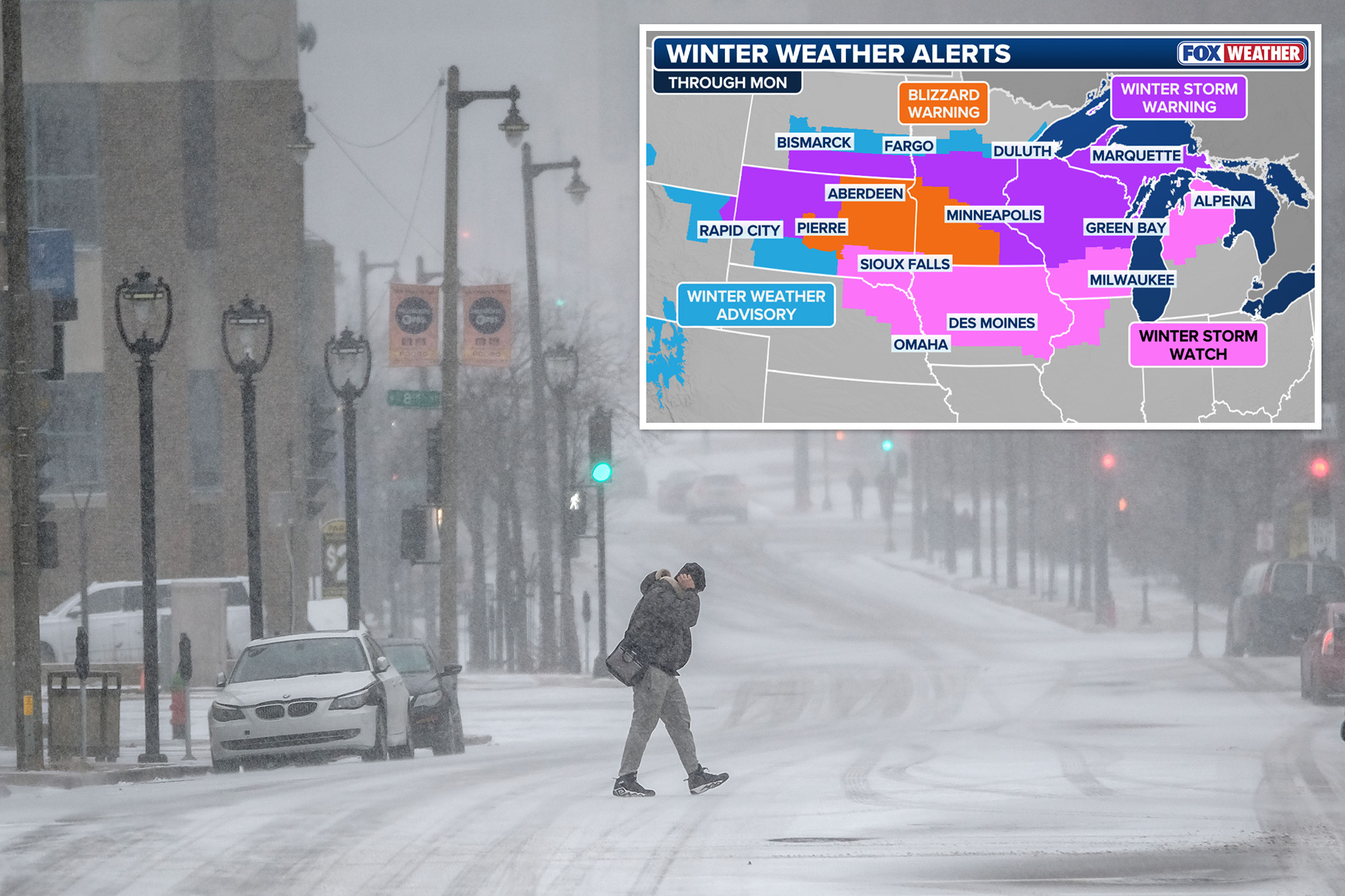
Millions across the Northern Tier are under Winter Weather Alerts, from Montana through Michigan.
Winter Storm Watches have been issued across much of the western Great Lakes, while areas in Minnesota, Wisconsin, South Dakota and Montana are already under Winter Storm Warnings.
Parts of South Dakota and western Minnesota are under Blizzard Warnings.
Ahead of the arrival of the threatening storms, flights have been proactively canceled in the Midwest in anticipation of the powerful storm that promises to cause travel troubles for regional travelers this weekend.
Due to significant forecasted snow and winds, Delta is processing cancellations at Midwest airports, including Delta’s Minneapolis-St. Paul hub, to ensure the safety of their customers, with more airlines likely to follow suit ahead of the dangerous storm.
Late Friday, a dip in the jet stream positioned across the Northwest pushed eastward into the Northern Rockies.
As this system moves into the Plains by Saturday, a surface low will develop and begin tracking into the Midwest and Great Lakes, packing wind gusts forecast to reach as high as 60–70 mph, providing the necessary ingredients for yet another strong storm in the North.
With high pressure remaining anchored over Canada, much cooler air will be ushered in behind this strengthening area of low pressure.
Start your day with all you need to know Morning Report delivers the latest news, videos, photos and more.
This colder air will allow precipitation across the Midwest to fall as snow and will likely expand into the Great Lakes region by Sunday.
The low will rapidly intensify as it moves into the Great Lakes.
The strong pressure gradient between the high to the north and the deepening area of low pressure will cause the winds to increase as well.
The heaviest snowfall is expected from eastern Minnesota through central Wisconsin into northern Michigan, where several feet of snow could fall by Monday evening.
This magnitude of snow may halt travel, severely disrupt cities, and cause power outages for thousands across the Great Lakes.
“We could see feet of snow. That is a lot of snow in areas that definitely do not need it. They’ve already gotten plenty of snow this winter,” FOX Weather Meteorologist Bayne Froney said.
As the area of low pressure moves into the Great Lakes, it will rapidly intensify as winds increase due to the strong pressure gradient, with a chance that it becomes a bomb cyclone as it moves further into Canada.
The combination of snow and strong winds will set the stage for blizzard conditions, reducing visibilities across Wisconsin, Minnesota and the Upper Peninsula of Michigan.
FOX Weather Meteorologist Jane Minar is in Traverse City, Michigan, covering the first of two strong storms moving through the region as snow falls in what is only the beginning of a strong, multi-day winter weather frenzy.
Just south of this heaviest snow, a wintry mix could deliver freezing rain and sleet impacting Milwaukee and south of the I-94 corridor, setting the stage for significant travel disruptions and dangerous road conditions.
Behind this system, a blast of cold air will settle, inviting any snow that falls to stick around.
Cold air surges back into the Plains and Midwest starting Monday, sending afternoon highs 15–25 degrees below average from the Canadian border all the way to the Texas–Mexico border.
Highs will struggle to reach the teens and 20s in the Midwest, with 40s and 50s across the Mid-South.
By early Tuesday, bitter wind chills will drop into the negative single digits and teens in cities like Minneapolis and Green Bay, while places such as Oklahoma City and Atlanta see wind chills in the teens and 20s.
A few record lows are possible across parts of the Deep South.