
$16,168,000
0 days on market
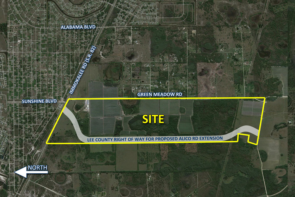
695 ACRES SR 82 FRONTAGE
PA Record: 12500 GREEN MEADOW RD
FORT MYERS, FL 33913
6.0Baths
46,048Sqft
186.26Acres
1990Built

 Description
One of the largest parcels available in the area.
The proposed Alico Road Extension, which would run through the parcel, would connect Lehigh Acres to the eastern end of Alico Road, giving Lehigh acres and Eastern Lee County easy access to the airport, shopping and Florida Gulf Coast University.
The proposed Alico Road Extension, which would run through the parcel, would connect Lehigh Acres to the eastern end of Alico Road, giving Lehigh acres and Eastern Lee County easy access to the airport, shopping and Florida Gulf Coast University.
 Property Overview
Property TypeMARKET VALUE AGRICULTURAL
Neural IDNR-DHTZJ71GJ-3D028B
STRAP14452600000010040
Folio ID10553316
ZoningAG-2
Land UseMARKET VALUE AGRICULTURAL
Legal DescriptionPARL LOC IN E 1/2 OF SEC LYING S OF SR 82 + S OF R/W
 Owner Information
JAMERSON FARMS ENTERPRISES LLC
 Data Transparency
75Verified Claims
Every data point has a verifiable source. This property has 75 government-sourced claims (Tier 1).
 Building Details
Living Area46,048 sqft
Bathrooms6.0
Stories1.0
Year Built1990
 Lot Details
Lot Size186.257 acres
ZoningAG-2
Exterior
 Exterior
 Transaction History
$3,244,300
$2,010,700
 Assessed Values
Market Value$4,698,743
Land Value$183,734
Building Value$861,233
 Location
Data Source Summary
Tier 1 - Government
75
Tier 2 - Professional
0
Tier 3 - Aggregator
0
 All Data Claims
| Field | Value | Source |
|---|---|---|
| agamount | 3649996.0 | Tier 1 |
| assessed | 1048747.0 | Tier 1 |
| assessed_value | "1048747" | Tier 1 |
| bathrooms | 6.0 | Tier 1 |
| bldgcount | 4.0 | Tier 1 |
| building | 861233.0 | Tier 1 |
| building_value | "861233" | Tier 1 |
| bxfv | 3780.0 | Tier 1 |
| carport | "Y" | Tier 1 |
| createyear | 2009.0 | Tier 1 |
| dorcode | 51.0 | Tier 1 |
| firedist | 54.0 | Tier 1 |
| firedistde | "LEHIGH ACRES FIRE DISTRICT" | Tier 1 |
| folioid | 10553316.0 | Tier 1 |
| garbdist | 3.0 | Tier 1 |
| garbtype | "N" | Tier 1 |
| gisacres | 186.257 | Tier 1 |
| has_carport | "true" | Tier 1 |
| heatedarea | 46048.0 | Tier 1 |
| just | 4698743.0 | Tier 1 |
| land | 183734.0 | Tier 1 |
| landusecod | 9910.0 | Tier 1 |
| landusedes | "MARKET VALUE AGRICULTURAL" | Tier 1 |
| land_value | "183734" | Tier 1 |
| latitude | 26.55999002 | Tier 1 |
| legal | "PARL LOC IN E 1/2 OF SEC LYING S OF SR 82 + S OF R/W" | Tier 1 |
| legal_description | "PARL LOC IN E 1/2 OF SEC LYING S OF SR 82 + S OF R/W" | Tier 1 |
| longitude | -81.68073047 | Tier 1 |
| lot_size_acres | "186.257" | Tier 1 |
| market_value | "4698743" | Tier 1 |
| maxbuilty | 2011.0 | Tier 1 |
| maxstories | 1.0 | Tier 1 |
| minbuilty | 1990.0 | Tier 1 |
| numunits | 186.26 | Tier 1 |
| o_addr1 | "2612 8TH ST W" | Tier 1 |
| o_city | "LEHIGH ACRES" | Tier 1 |
| o_name | "JAMERSON FARMS ENTERPRISES LLC" | Tier 1 |
| o_state | "FL" | Tier 1 |
| owner_name | "JAMERSON FARMS ENTERPRISES LLC" | Tier 1 |
| o_zip | 33971.0 | Tier 1 |
| rendate | "2009-11-12" | Tier 1 |
| renstrap | 14452600000010000 | Tier 1 |
| s_1amount | 3244300.0 | Tier 1 |
| s_1date | "2002-08-30" | Tier 1 |
| s_1or_num | "-B3719-P1331-" | Tier 1 |
| s_1tc | 5.0 | Tier 1 |
| s_1toc | 4.0 | Tier 1 |
| s_1vi | "V" | Tier 1 |
| s_2amount | 2010700.0 | Tier 1 |
| s_2date | "1980-09-01" | Tier 1 |
| s_2or_num | "-B1456-P1278-" | Tier 1 |
| s_2tc | 2.0 | Tier 1 |
| s_2toc | 2.0 | Tier 1 |
| s_2vi | "V" | Tier 1 |
| sale_1 | "{\"date\": \"2002-08-30\", \"amount\": 3244300, \"instrumen | Tier 1 |
| sale_2 | "{\"date\": \"1980-09-01\", \"amount\": 2010700, \"instrumen | Tier 1 |
| siteaddr | "12500 GREEN MEADOW RD" | Tier 1 |
| sitecity | "FORT MYERS" | Tier 1 |
| sitenumber | 12500.0 | Tier 1 |
| sitestreet | "GREEN MEADOW RD" | Tier 1 |
| sitezip | 33913.0 | Tier 1 |
| square_feet | "46048" | Tier 1 |
| stories | "1.0" | Tier 1 |
| strap | 14452600000010040 | Tier 1 |
| taxable | 1048747.0 | Tier 1 |
| taxable_value | "1048747" | Tier 1 |
| taxdistdes | "LEHIGH ACRES FIRE" | Tier 1 |
| taxingdist | 49.0 | Tier 1 |
| totalarea | 53952.0 | Tier 1 |
| total_area | "53952" | Tier 1 |
| trsparcel | 45261400000010040 | Tier 1 |
| unitofmeas | "AC" | Tier 1 |
| year_built | "1990" | Tier 1 |
| zoning | "AG-2" | Tier 1 |
| zoningarea | "ULC" | Tier 1 |