
$0
0 days on market
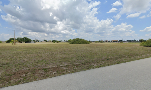
1122 NW 17TH ST
CAPE CORAL, FL 33993
2,023Sqft
0.23Acres
2024Built

 Description
1.83-acre (±79,715 SF) mixed-use development site in Northeast Cape Coral zoned CC (Commercial Corridor). The sale includes site plan–approved architectural plans for a two-building, three-story mixed-use project totaling approximately 56,344 square feet. The proposed development consists of 52 residential units (42,744 SF) and approximately 13,600 square feet of ground-floor commercial space designed to support neighborhood-serving retail and service uses. The project spans two contiguous parcels and is positioned within the Northeast Cape Coral growth corridor with direct access to Del Prado Boulevard and Pine Island Road, two of the area’s primary commercial and commuter arteries.
 Property Overview
Property TypeVACANT RESIDENTIAL
Neural IDNR-DHTXY1DUR-961456
STRAP344323C3029270110
Folio ID10041878
ZoningR1
Land UseVACANT RESIDENTIAL
Legal DescriptionCAPE CORAL UNIT 42 BLK 2927 PB 17 PG 34 LOTS 11 + 12
 Owner Information
COOLEY GARY G +
COOLEY KATHLEEN A
 Data Transparency
45Verified Claims
Every data point has a verifiable source. This property has 45 government-sourced claims (Tier 1).
 Building Details
Living Area2,023 sqft
Year Built2024
 Lot Details
Lot Size0.230 acres
ZoningR1
Exterior
 Exterior
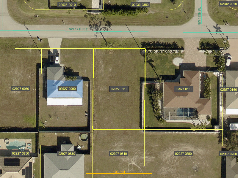 Tax map
No Sales History
 Assessed Values
Market Value$33,915
Land Value$33,915
 Location
Data Source Summary
Tier 1 - Government
45
Tier 2 - Professional
0
Tier 3 - Aggregator
0
 All Data Claims
| Field | Value | Source |
|---|---|---|
| assessed | 11859.0 | Tier 1 |
| assessed_value | "11859" | Tier 1 |
| co_owner_name | "COOLEY KATHLEEN A" | Tier 1 |
| createyear | 1900.0 | Tier 1 |
| depth | 125.0 | Tier 1 |
| firedist | "CCC" | Tier 1 |
| firedistde | "CITY OF CAPE CORAL" | Tier 1 |
| folioid | 10041878.0 | Tier 1 |
| frontage | 80.0 | Tier 1 |
| garbdist | 17.0 | Tier 1 |
| gisacres | 0.23 | Tier 1 |
| just | 33915.0 | Tier 1 |
| land | 33915.0 | Tier 1 |
| landusedes | "VACANT RESIDENTIAL" | Tier 1 |
| land_value | "33915" | Tier 1 |
| latitude | 26.683777 | Tier 1 |
| legal | "CAPE CORAL UNIT 42 BLK 2927 PB 17 PG 34 LOTS 11 + 12" | Tier 1 |
| legal_description | "CAPE CORAL UNIT 42 BLK 2927 PB 17 PG 34 LOTS 11 + 12" | Tier 1 |
| longitude | -81.997835 | Tier 1 |
| lot_size_acres | "0.23" | Tier 1 |
| market_value | "33915" | Tier 1 |
| numunits | 1.0 | Tier 1 |
| o_addr1 | "4685 IDE RD" | Tier 1 |
| o_city | "WILSON" | Tier 1 |
| o_name | "COOLEY GARY G +" | Tier 1 |
| o_others | "COOLEY KATHLEEN A" | Tier 1 |
| o_state | "NY" | Tier 1 |
| owner_name | "COOLEY GARY G +" | Tier 1 |
| o_zip | 14172.0 | Tier 1 |
| rendate | "1997-01-26" | Tier 1 |
| renstrap | "344323A1029270110" | Tier 1 |
| siteaddr | "1122 NW 17TH ST" | Tier 1 |
| sitecity | "CAPE CORAL" | Tier 1 |
| sitenumber | 1122.0 | Tier 1 |
| sitestreet | "NW 17TH ST" | Tier 1 |
| sitezip | 33993.0 | Tier 1 |
| strap | "344323C3029270110" | Tier 1 |
| taxable | 11859.0 | Tier 1 |
| taxable_value | "11859" | Tier 1 |
| taxdistdes | "CITY OF CAPE CORAL" | Tier 1 |
| taxingdist | 57.0 | Tier 1 |
| trsparcel | "432334C3029270110" | Tier 1 |
| unitofmeas | "UT" | Tier 1 |
| zoning | "R1" | Tier 1 |
| zoningarea | "CCC" | Tier 1 |